Inca Trail day 4, Intipata to Machu Picchu (Peru)

Hi !

Final day of this epic journey to the world’s 7th wonder, the Machu Picchu, it is also the most relaxed one. Only about 6 km to walk, mostly flat (or Andean flat, which means a bit up or a bit down).

Hiram Bingham discovered the Machu Picchu before he found the trail(s) leading to it. After cleaning up the Machu Picchu, he followed a trail and found the Sun Gate, and kept following that trail a uncovered the Inca Trail as we know it today. Then the consensus was that there was only one path to Machu Picchu, though by now 7 more have been found, going in various directions.

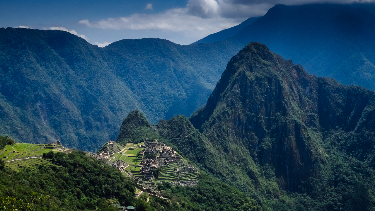
Arriving at the Sun Gate is a magical thing. First because there’s a horde of regular tourists who came by the bus station, and they only can have this view by hiking up the gate. Second because the view is just insane, though here apparently we were exceptionally lucky to have another crystal clear blue sky.

Of course, when you continue from the gate to the Machu Picchu, the magic goes away for you realise you are now one of the 3000 other tourists there. The feeling is weird as having done the walk to get to enjoy it, I sort of felt more entitled than the rest of been there… however the only advantage I had was that I could just scream that I haven’t shower for four days to get some space when the crowed thickened.

This journey was by far the best trekking I’ve done in my life… Sure this is not a private and true nature experience, but walking through this incredible landscape, on a road build some 600 years ago, passing through ruins and feeling the glorious past of the Incas is just plain awesome.

Enjoy (or not) and stay tuned !


Inca Trail day 3, Pacaymayo to Intipata (Peru)

Hi !

The third day is synonym of high jungle (and rain forest), which is basically jungle in the mountain, a concept that is mostly possible for Peru is a tropical country. It also means a lot more Inca ruins, all hidden in the lush green vegetation of this high jungle, so it has an Indiana   Jones feeling that I must admit, made it the best day on this trail.

But before you get to enjoy it, there’s the usual climb of these steep stair to begin with, in order to deal with the Runkuraqay pass (3900masl). We were all sort of scared, for the previous day left us with sore bodies, but it turned out to be rather easy climb, with terrific view on a beautiful ruin. Our guide promised us that it would be the last difficulty for the trip.

Once the pass was dealt with, the day lived up to our expectation. Ruins after ruins, gringo killer stairs after gringo killer stairs, tunnels carved in huge granite rocks, gorgeous views, and the green vegetation only missing birds singing and monkeys screaming, the journey to Machu Picchu became the adventure we were looking for, full of stories on how Hiram Bingham discovered all this forgotten heritage.

Cherry on the cake, as we were in a rain forest, it is rare to have a dry day there… we were the lucky ones, it was such a great weather to hike: crystal clear blue sky and comfortable temperatures !

Now I could have show you all of that, instead, but it turns out I kinda suck at shooting ruins, so instead I’ll leave you with the busy activity on one of the resting stops, where most groups (but not us) usually have lunch on that day.

Would I do the Inca Trail again ? For that day I’m tempting to say “yes, yes and yes !”…

Enjoy (or not) and stay tuned !

Inca Trail day 2, Wayllabamba to Pacaymayo (Peru)

Hi !

Oh that second day ! No ruins, nothing to learn about the Inca except that the stairs they built are steep, and there are so many of them to climb !! 1200m elevation gain to reach the Warmiwañuscca (Dead Woman) pass at 4200masl, with the joy of fighting against the thin air !!!

Surprisingly, considering the night camping and my previous experience at high altitude, we made it rather easily up there. It takes usually 5 hours to climb up and 2 hours to climb down to the next camp, and we needed 4 hours for the uphill section (including the breaks) and 1h15 for the downhill section. The weather was spectacularly good, so we where able to enjoy 30 minutes of view, until another reality hit us: we need food (we purposely decided not to have a lunch break half way through the climb to not deal with digestion during the steepest sections) !

As you can imagine, the obvious reward for all this effort is the view. On one side (not the picture above), there’s the view on the Wayanay glacier; on the other side (the above picture), the view on a valley and the what will be tomorrow challenge: the Runkuraqay pass (at 3900masl). This section of the Inca Trail is about the spiritual journey, as the mountain are sacred for the Incas, and while I haven’t found my religion, I would definitively agree that there’s something majestic about these mountains.

I cannot leave this post without a picture of the Wayanay Glacier…

Inca Trail day 2 (Wayanay Glacier)

Enjoy (or not) and stay tuned !


Inca Trail day 1, km 82 to Wayllabamba (Peru)

Hi !

This is the first of the 4 articles about the highlight of my first time in the Peru: the Inca Trail. Starting from km 82 (at the train station close to Ollantaytambo), the first day is all about climbing from a low 2600masl to 3000masl and acclimate for the next day.

So a gentle day in essence, good to stretch the legs and enjoy some Inca ruins and a rather dry weather. It is also a great opportunity to take a look at the Salcantay glacier, though frequently covered with clouds (just like on this picture). There are a few ruins along the way, some a bit far and some you’ll pass right through. The camping site of that night was incredibly well located, with a beautiful view on the Wayanay glacier (in front of us) and the Veronica glacier (on the left side). There was also a view on the daunting Warmiwañuscca pass, also know as the Dead Woman pass…

When I have cleaned the GPS trace properly, I’ll add the detail about the journey to this post. Until so, I’ll leave you with this picture taken at the very beginning of the day.

Enjoy (or not) and stay tuned.