Inca Trail day 3, Pacaymayo to Intipata (Peru)

Hi !

The third day is synonym of high jungle (and rain forest), which is basically jungle in the mountain, a concept that is mostly possible for Peru is a tropical country. It also means a lot more Inca ruins, all hidden in the lush green vegetation of this high jungle, so it has an Indiana   Jones feeling that I must admit, made it the best day on this trail.

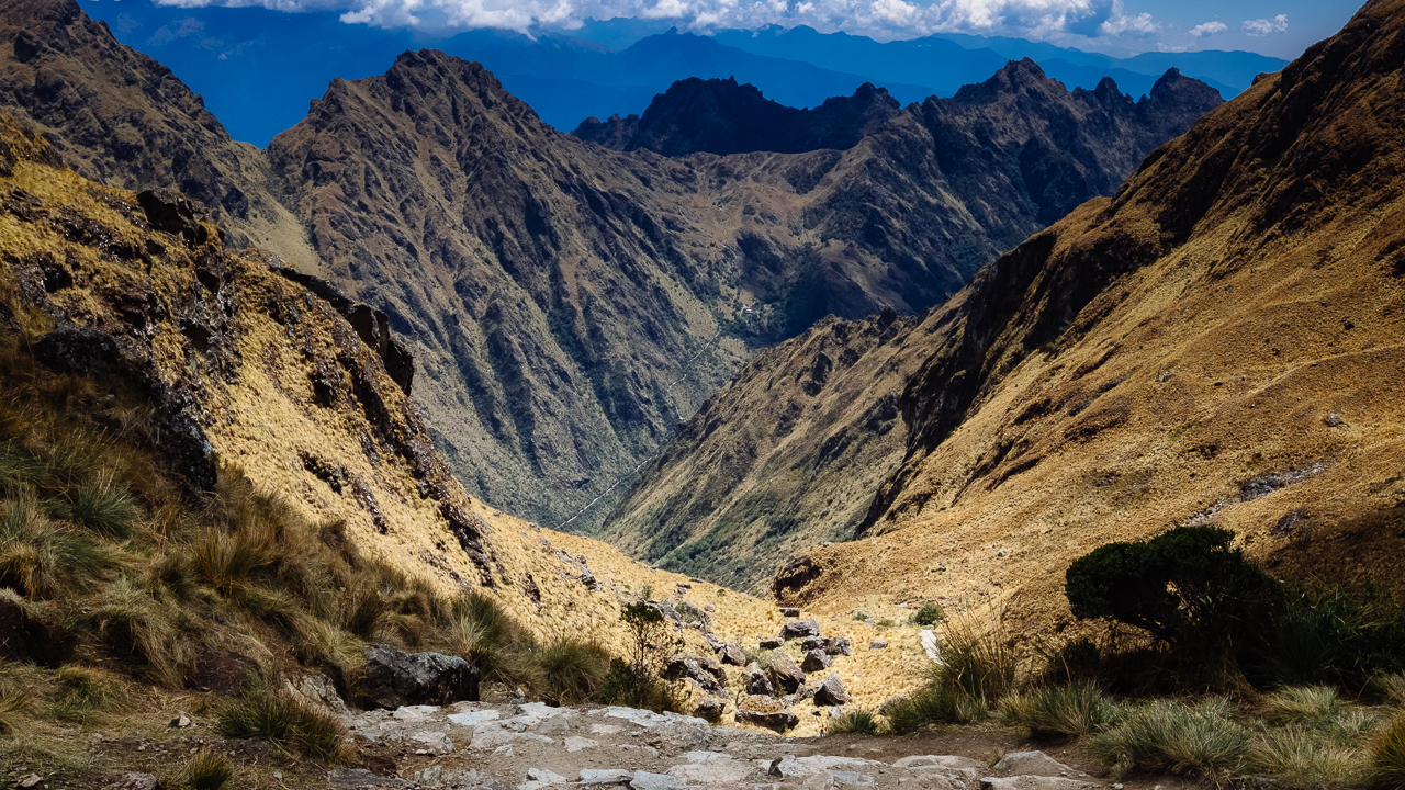
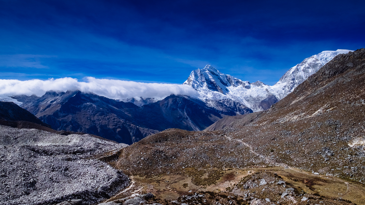
But before you get to enjoy it, there’s the usual climb of these steep stair to begin with, in order to deal with the Runkuraqay pass (3900masl). We were all sort of scared, for the previous day left us with sore bodies, but it turned out to be rather easy climb, with terrific view on a beautiful ruin. Our guide promised us that it would be the last difficulty for the trip.

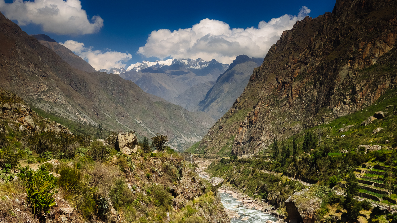
Once the pass was dealt with, the day lived up to our expectation. Ruins after ruins, gringo killer stairs after gringo killer stairs, tunnels carved in huge granite rocks, gorgeous views, and the green vegetation only missing birds singing and monkeys screaming, the journey to Machu Picchu became the adventure we were looking for, full of stories on how Hiram Bingham discovered all this forgotten heritage.

Cherry on the cake, as we were in a rain forest, it is rare to have a dry day there… we were the lucky ones, it was such a great weather to hike: crystal clear blue sky and comfortable temperatures !

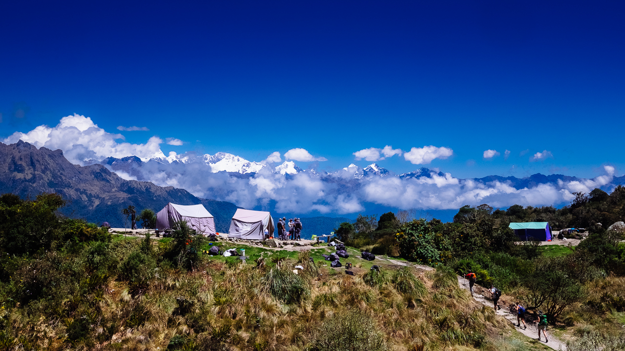
Now I could have show you all of that, instead, but it turns out I kinda suck at shooting ruins, so instead I’ll leave you with the busy activity on one of the resting stops, where most groups (but not us) usually have lunch on that day.

Would I do the Inca Trail again ? For that day I’m tempting to say “yes, yes and yes !”…

Enjoy (or not) and stay tuned !

Inca Trail day 2, Wayllabamba to Pacaymayo (Peru)

Hi !

Oh that second day ! No ruins, nothing to learn about the Inca except that the stairs they built are steep, and there are so many of them to climb !! 1200m elevation gain to reach the Warmiwañuscca (Dead Woman) pass at 4200masl, with the joy of fighting against the thin air !!!

Surprisingly, considering the night camping and my previous experience at high altitude, we made it rather easily up there. It takes usually 5 hours to climb up and 2 hours to climb down to the next camp, and we needed 4 hours for the uphill section (including the breaks) and 1h15 for the downhill section. The weather was spectacularly good, so we where able to enjoy 30 minutes of view, until another reality hit us: we need food (we purposely decided not to have a lunch break half way through the climb to not deal with digestion during the steepest sections) !

As you can imagine, the obvious reward for all this effort is the view. On one side (not the picture above), there’s the view on the Wayanay glacier; on the other side (the above picture), the view on a valley and the what will be tomorrow challenge: the Runkuraqay pass (at 3900masl). This section of the Inca Trail is about the spiritual journey, as the mountain are sacred for the Incas, and while I haven’t found my religion, I would definitively agree that there’s something majestic about these mountains.

I cannot leave this post without a picture of the Wayanay Glacier…

Inca Trail day 2 (Wayanay Glacier)

Enjoy (or not) and stay tuned !


Inca Trail day 1, km 82 to Wayllabamba (Peru)

Hi !

This is the first of the 4 articles about the highlight of my first time in the Peru: the Inca Trail. Starting from km 82 (at the train station close to Ollantaytambo), the first day is all about climbing from a low 2600masl to 3000masl and acclimate for the next day.

So a gentle day in essence, good to stretch the legs and enjoy some Inca ruins and a rather dry weather. It is also a great opportunity to take a look at the Salcantay glacier, though frequently covered with clouds (just like on this picture). There are a few ruins along the way, some a bit far and some you’ll pass right through. The camping site of that night was incredibly well located, with a beautiful view on the Wayanay glacier (in front of us) and the Veronica glacier (on the left side). There was also a view on the daunting Warmiwañuscca pass, also know as the Dead Woman pass…

When I have cleaned the GPS trace properly, I’ll add the detail about the journey to this post. Until so, I’ll leave you with this picture taken at the very beginning of the day.

Enjoy (or not) and stay tuned.

Moray (Peru)

Hi !

If for most people Moray is all about these round terraces the Incas built to farm experimental crops of corn and potato, I was a lot more interested by the view of the glacier on the other side.

The Inca site itself is really nice, though probably not that high in the list of thing to see, for it is just terrace and a short 30 minutes of explanation. The round terraces (or so they look) are impressive, but a lot is left free to imagine, for there are few hard evidence (and next to no documentation) of what this site was really about.

Enjoy (or not) and stay tuned !

Inca Trail through the Sacred Valley (Peru)

Hi !

Well, this picture is not really showing much about the Inca Trail itself, but it sort of lay the expectations for what will be this incredible journey through Peru most sacred area. The Incas, aware that the spanish will make an attempt at conquering this part of Peru, decided to remove the trace of the road leading to Machu Picchu (which was sort of paved), successfully hiding the most sacred of all site. It is only several centuries later, in the early 1900, that Hiram Bingham discovered what would become the Inca Trail, subsequently leading him to the Machu Picchu. To be fair, it is likely that others knew about the site, but he was the one discovering it for us.

Therefore, this site has the particularity of having been left alone for centuries (as it was forbidden to non noble Incas to go there, it really got forgotten). When I’ll see a running fountain, I should pay my respect to the engineer who built it to last un-maintained for that long !

But before talking about the coming adventure, I need to give you my impression on the Sacred Valley. Though I learnt a little bit about the Inka, it is mostly ruins. And before you get the chance to visit them, there’s the mandatory passage through the various souvenir stores, all showing handcrafted stuff that could not look any less handcrafted. So much potential waisted in trying to rip the tourist. The ruins themselves are sort of repetitive, and really what makes it so special is probably the surrounding landscape.

Back to the main story !

So seven days from now I’ll be putting my foot on the Inca Trail, following an old road laid by the Incas to take us from km 82 (Piscacucho) to the Machu Picchu, some 48km away. It will require us to pass a 4200masl pass (known as the Dead Women Pass), and climbing down some 2000 stairs. As I’m not in my prime years anymore, we took the 5 days options, which would mean a lot of time up there taking photos and watching endless flows of clouds passing the giants surrounding us. There’ll be also porters and cookers, so really it just about as adventurous as trying to score a decent meal in Paris. The barely freezing temperature at nights will just make any visit to the bathroom very well calculated.

Day 1: We’ll start at some 2400masl and walk some 10km to the first campsite, Hatuncacha, at some 2900masl.

Day 2: We’ll walk some 16.5km, pass the Warmiwañusca (Dead Women Pass) at 4215masl and finish at the second campsite, Pacaymayo, at some 3630masl

Day 3: We’ll walk some 11km, pass the Runkuracay (second pass) at 3900masl and finish at the third campsite, Phuyupatamarka, at some 3640masl.

Day 4: We’ll walk some 11km, going down to our third campsite, Puente Ruinas at some 2030masl.

Day 5: No walking, just catching the bus to be among the first to the Macchu Picchu.

There will be plethora of ruins and curiosity along the way. I’m gonna say the Condors will be looking at me like some potential diner, for I’m absolutely not fit, but if I can give a little something back to nature…

Enjoy (or not) and stay tuned !

Active volcano (Peru)

Hi !

Peru is one of this country that offers a huge variety of climate and landscape, from desert to tropical jungle, mountains and plateau higher that the highest peak in Europe. Driving (or been driven) in this environment is really an experience by itself, especially when you arrive at some 4900masl and see 8 volcanoes around you.

One of them was showing some activity, not really sure if this is just a production of steam, toxic gazes or the premises of a violent eruption. The story remains to be written on that.

Volcanoes and peaks all bear a huge importance for the Incas and pre-Incas, believing they were spirit protecting them. Yet most city stories usually are marked by the violence of the earthquakes and eruptions, which (if you have to look at the bright side) were reasons for them to improve their building technic and selection of location to establish new settlement.

Enjoy (or not) and stay tuned !

The flight of the condor (Peru)

Hi !

Certainly a cliché, but can you really visit Peru and miss the flight of the condor. I guess not. So I went on what I can tell you I hate the most: a guided tour to Canyon del Colca, with the expected stop at Cruz del Condor, a lookout located where the Canyon gets as deep as 3400m, a place where condors love to glide.

Sure we were several hundreds, all attempting to capture a photo of the magnificent bird, and I would like to think I wasn’t the worst. I could have done better if I would have drop a rotten body for them to eat and get close to me, but I was way to found of my traveling buddy to do that to her.

Enjoy (or not) and stay tuned !

Mirador de los Andes (Peru)

Hi !

There are a few roads on earth that you’ll always hear people saying that you have to drive them (or been driven on them) once in your life: the West Coast Highway in New Zealand, the Great Ocean Road in Australia, … I would add the one between Arequipa and Chivay.

First, because how many times in your life will you drive over the Mont Blanc, which is what happens when you reach the Mirador de los Andes (4910masl). Second because you’ll pass next to vicuñas while enjoying beautiful volcanos, some probably active. The landscape is incredible, making it obvious that it is hostile to many form of life (trees and humans most definitively).

The above picture was shot at the Mirador de los Andes, aiming at the Cordillera Chilena. The air here is as pure as it gets. Roads seems to leads to the far away mountains, but will drop to the valley below at some 3600masl. The snow is usually appearing above 5000masl, if you want an idea of the size of these giant in front of us.

Enjoy (or not) and stay tuned !

Road from Huaraz to Conococha (Peru)

Hi !

Not all the places live up to one’s expectation, but Huaraz definitely did. So when it was time to leave it for Lima (awfully grey at this time of the year), the best thing to do was to depart as early as possible to enjoy some great views on the Cordillera Blanca with the morning sun.

This photo was taken a few kilometers from Conococha, at something like 4100masl. The snow usually start around 5000masl, so you can judge that the peaks here are definitely not easy one to conquer, and yet they are not the biggest one. The amazing part is that it is sort of a plateau (or we could call it a big mountain flat on top) with other mountains sitting on top it.

I’ll keep a great souvenir of the Cordillera Blanca (and Negra, on the other side of the road), even though we could not reach all the places we wanted to, since a better fitness level and some mountaineering skills are a requirement. Just the view by itself made it worth it. In about 100km from there, the lush green of the valley will become sand and dust, and the beautiful blue sky will become a grey fog.

Enjoy (or not) and stay tuned !

Laguna 69: Soroche 1 – Greg 0 (Peru)

Hi !

El soroche (high altitude or mountain sickness) is something probably more of a legend for the Peruvians, but for a guy born and raised at 600masl (meter above sea level) and who has climbed the Vosges mountains (or hills would be more accurate) for the most part of his life, it will be a very bad experience. Fortunately, if I can say so, it wasn’t while doing the Everest that I had to face it.

We wanted to hike to Laguna 69, so following some recommendations, we decided to do it in two steps: day 1 we hike to Refugio Peru/Pisco, starting from 3900masl, then reaching 4700masl after some 5km, and day 2, we climb over a 5000masl pass to hike downhill to the laguna and then back to the trail head.

We did the climb to the Refugio in about 4h20 (accounting for more than 2h of breaks and catching my breath). When we passed the 4400masl, a strange feeling similar to light panic attacks and light fever starting to hit us. But it was easier to continue than going back, since there would be no car waiting for us and we could just freeze overnight. So we continued, and it was worst: the panic attack and fever feelings got worst, then came the headache and dizziness. We felt like shit !

The Refugio was however a pleasant surprise. First there’s the insane view, with the Pisco, the Huantoy and Huscaran peaks visible. operated by benevolences, with premium quality accommodation, I would say it wasn’t the worst place to rest and wait for the body to fight back the soroche. I would have hated to do that in a tent. We met there a few people, all having next to no issues with been that high. I won’t even talk about the Peruvian porters, who carried more than 50km and made the climb in less than two hours, no breaks unless they have to wait for their customers.

Anyway, it sort of killed the mood, and feeling that bad (and somewhat reminded of our lack of fitness), we decided not to attempt the Laguna 69 the next day, since passing a 5000masl pass was involved. We also decided to not do the Santa Cruz trek, as clearly we would not properly acclimate, since we are staying below 2500masl. This hike to the Refugio would probably have been a success if we would have slept a night at 3900masl, to acclimate properly.

So here it is, another failed attempt. I wouldn’t say it should mean no more high mountain, but doing better preparation definitively.

Enjoy (or not) and stay tuned.

1 2 3 4 5