Patagonian step (Argentina)

Hi !

To give an idea of how empty can be South Patagonia on the Argentina side (the Chubut and Santa Cruz Province), we are talking of a territory roughly the size of France, with less than 1% if is population, so around 1.5 habitant per square kilometer. So in other words: a desert, with population pushed either on the mountain side (the border with Chili) or the coast side. So what is there to look at ? storms !

Rainy_Patagonia_step.jpg
Rainy Patagonia step

Enjoy (or not) and stay tuned !

Torres del Paine (Chile)

Hi !

I knew Parque Nacional Torres del Paine would be one of the highlight of this journey in South America. Trekking the W circuit was incredible, but left me unsatisfied of not spending more time chilling in the wonder of nature. So I came back for another three days.

Instead of going through a lengthy description, I’ll leave you with the picture I took from various viewpoint (mirador) during this second trip to the park.

Torres del Paine from Villa Rio Serrano
Torres del Paine (from Villa Rio Serrano)
Torres del Paine from Mirador Rio Serrano
Torres del Paine (from Mirador Rio Serrano)
Paine Grande from Hotel Lago Grey
Paine Grande (from Hotel Lago Grey)
Torres del Paine from Rio Serrano
Torres del Paine (from Rio Serrano)
Los Cuenos
Los Cuernos
Los Cuernos from Mirador Cuernos
Los Cuernos (from Mirador Cuernos)
Torres_del_Paine_from_Mirador_Lago_Sarmiento.jpg
Torres del Paine (from Mirador Lago Sarmiento)

I only regret not seeing the other side of this mountain. I should eventually return in a few years to try the O circuit (plus a couple other trek and some kayaking). The good part is that been familiar with this park now, it should be rather easy to plan for it.

Enjoy (or not) and stay tuned !

Tierra del Fuego (Chile / Argentina)

Hi !

Located in the southernmost part of the world before reaching Antarctica, la Tierra del Fuego, a.k.a. The End of the World, is a land of adventure and cold wet windy weather. Here boats sink, people live in eternal winters, king crab is the best food and the nature rules ! It is also a place where the natives lived almost naked, using fires to keep warm, thus giving the name the place when the first sailors passed by and saw these fire from their boats.

As you drive from Puerto Natales (or Punta Arenas) to Tierra del Fuego, first comes the realisation of all the shipwrecks that built the myth. If most ships are now decomposing on the bottom of the oceans, seas and channels, so are forever part of the littoral. Reaching the ferry later made it clear that the strong currents are not for beginners.

Shipwreck_in_Patagonia.jpg

The southern part of the Tierra del Fuego is where the Andes ends. If in Peru the free air freezing zone (or bush line) is above 5000masl, here you only have to climb 700masl to enjoy all year round snow.

Roads_of_Tierra_del_Fuego.jpg

If I haven’t enjoyed Ushuaia as much as I should have, according to my traveling partner, the Parque Nacional Tierra del Fuego was a better surprise, the best chance to observe the vibrant green vegetation and a landscape shaped thousands of years ago by glacier.

Blooming vegetation of Parque Nacional Tierra del Fuego
Beagle Channel
Beagle Channel
Laguna Roca
Laguna Roca

Now at that point you may be noticing the grey cloudy sky and wonder if there’s any chance to see something more summer like. In short, yes, but only for a few minutes, for the wind will always end up bringing back these clouds.

Estancia_Caleta_Josefina.jpg

If I don’t have a lot of positive stuff to say about Ushuaia, I should write that my opinion is not mainstream. Many enjoy the city more than I did. However, something should be said about the king crab, and that I had the best ones there. So if this is something you are looking for, do not avoid Ushuaia.

Enjoy (or not) and stay tuned !


Torres del Paine day 5 – Mirador de las Torres

Hi !

The name of the park come from 3 towers, vertical granite peak shapes by almost every form of erosion: glacier, snow and ice, rain and wind.

But even if they are the main reason to visit this park, they are not easy to reach, especially on the last day of a 4 days trek. Indeed we gave up, for my legs and back could not take it anymore, a testimony of my fitness.

But if we couldn’t see the holy grail, we were still blessed by a rather beautiful day, and terrific views in the Valle del Ascencio, such as the one above.

The main mistake is not so much my fitness, but the fact that we didn’t bring day pack for making this strenuous hike easier. So one of us (guess who) had the big multi day pack with all the stuff that couldn’t be left at the camp, and this gave up half way.

Don’t feel bad though, a return visit is already planned and this time only doing the climb to the Torres del Paine in one day. And if i still give up, then I just may stop pretending I like hiking and move to a more sofa oriented lifestyle !

Enjoy (or not) and stay tuned !

Torres del Paine day 4 – Campamiento del Frances to Campamiento Torres Central (Chile)

Hi !

The Torres del Paine is known for its 4 seasons in a day Patagonian weather, but summer also sometimes happen for a full day. Suddenly the color are vibrant, the nature is peaceful and every insects and birds get very busy enjoying this beautiful ecosystem.

Featured above was the highlight of the day, the stop by the Lago Nordenskjöld, a rather cold body of water, so quiet and clear.

As we keep moving east, there was a last chance to glimpse at the Paine Grande, before it would disappear.

Paine_Grande.jpg

Once we reached the Hotel Las Torres (just a kilometer before the campsite), it seems like it was a different park. No more big lakes, glaciers, trees tortured by the wind and alpine like vegetation, but green plaines, pine trees, grass and farm land. The Torres del Paine (not the park but the towers themselves) were now visible, which would be tomorrow highlight, if we make it up there.

Just to show you how clear the sky was on that day, here’s a view of the Cerro Ferrier and Cerro Donoso, so far away and yet very visible.

Cerro_Ferier_and_Cerro_Donoso_from_far_away.jpg

Now, probably a consequence of been lazy, tired and slighly dehydrated, I did not even realized until looking at my photos at the end that I did not shoot a single photo of the Monte Almirante Niento or the Torres del Paine from the campsite…

Enjoy (or not) and stay tuned !

Torres del Paine day 3 – Refugio Paine Grande to Campamiento del Frances (Chile)

Hi !

The third day is all about climbing to the Valle del Frances, which sits between the Paine Grande and the Cuernos. First, a 7.5km walk through a dead forest, tragedy of the 2011 accidental fire, passing a few lakes, with beautiful views on the Cuernos (seen above). Then, it’s a 5.4km climb with 900m of elevation gain to reach the Mirador Britanico.

As you climb, a first stop will offer spectacular views on the Glaciar del Frances, a hanging glacier on the Paine Grande hill. We could hear the lound sound of avalanches, but all seemed to be happening on the other side of the mountain (don’t worry though, the path is far away enough to stay safe).

Glaciar del Frances

Then, a flat section at around 500masl opens on the Valle del Frances, with an amazing scenery. The vegetation here is amazing, not just because it offers some protection against the wind, but for resisting harsh weather conditions all year round.

Valle del Frances

I would love to show you the view from the Campamiento Britanico, but a combination of fitness issues and strong winds made us turn back. We were told later that the view would not get much better (if anything it would give less change to grab the panorama).

The only regret was that as we started to descend, the bad weather was clearing and the wind started to reduce. But on the other hand, with another two days to walk, it was probably better to avoid a few kilometers.

Enjoy (or not) and stay tuned !

Torres del Paine day 2 – Refugio Lago Grey to Refugio Paine Grande (Chile)

Hi !

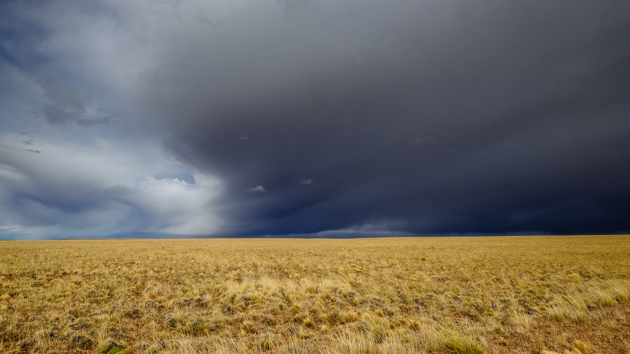
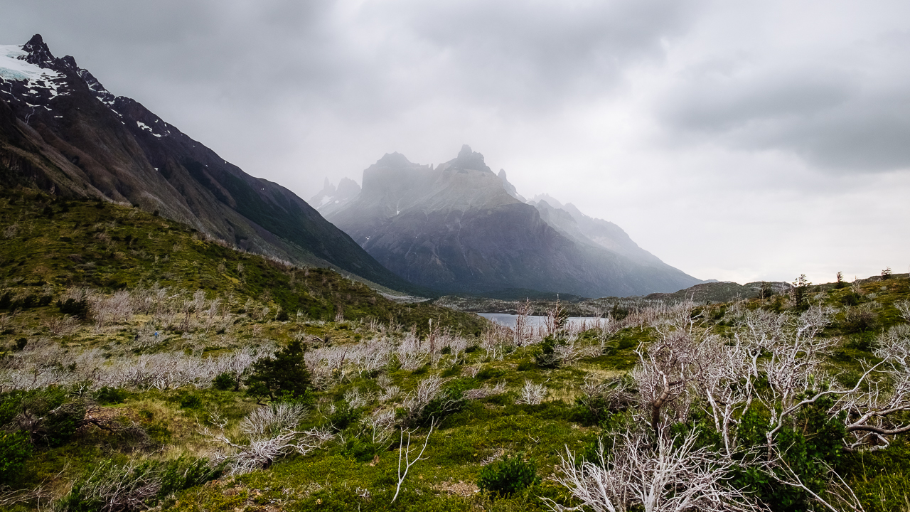
The first day of trekking started with an 11km journey from Refugio Grey to Refugio Paine Grande, along the Lago Grey, through a vegetation that is not really living the dream, weather condition wise. Here winds are strong and cold. The weather is changing constantly, wet for a few minutes, sunny for a few other. If you consider the rocky sandy soil that sucks water in no time, every single green thing here fights for saving water.

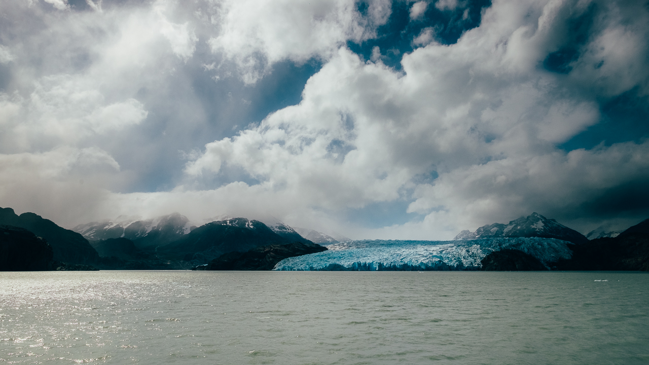
We started by doing a 2km (each way) detour to the first hanging bridge to get a view on the Grey Glacier before we would leave it to reach the Refugio Paine Grande, our overnight stop.

Grey Glacier from the W circuit

Even though the wind wasn’t the strongest, it lived up to the expectation. All the way to the shelter we were constantly pushed by gusts of 60km/h to 80km/h, sometimes deciding for us where our feet would land. It may sound risky, but apart from a short fall, nothing life threatening here. However the cold feeling was insane. I would say that the air temperature was between 15°C and 18°C, but the wind made it fall below 10°C easily.

As an example, Laguna Los Patos would be the most peaceful still water lake, if the winds wasn’t creating waves like you would have on a sea.

Laguna Los Patos

As we progressed, we reached a low pass that connects the Lago Grey side to the Lago Pehoe side, where the winds seemed to accelerate even more. This part was actually fast to cross, with such a push in the back.

Lago Pehoe

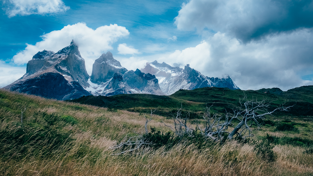
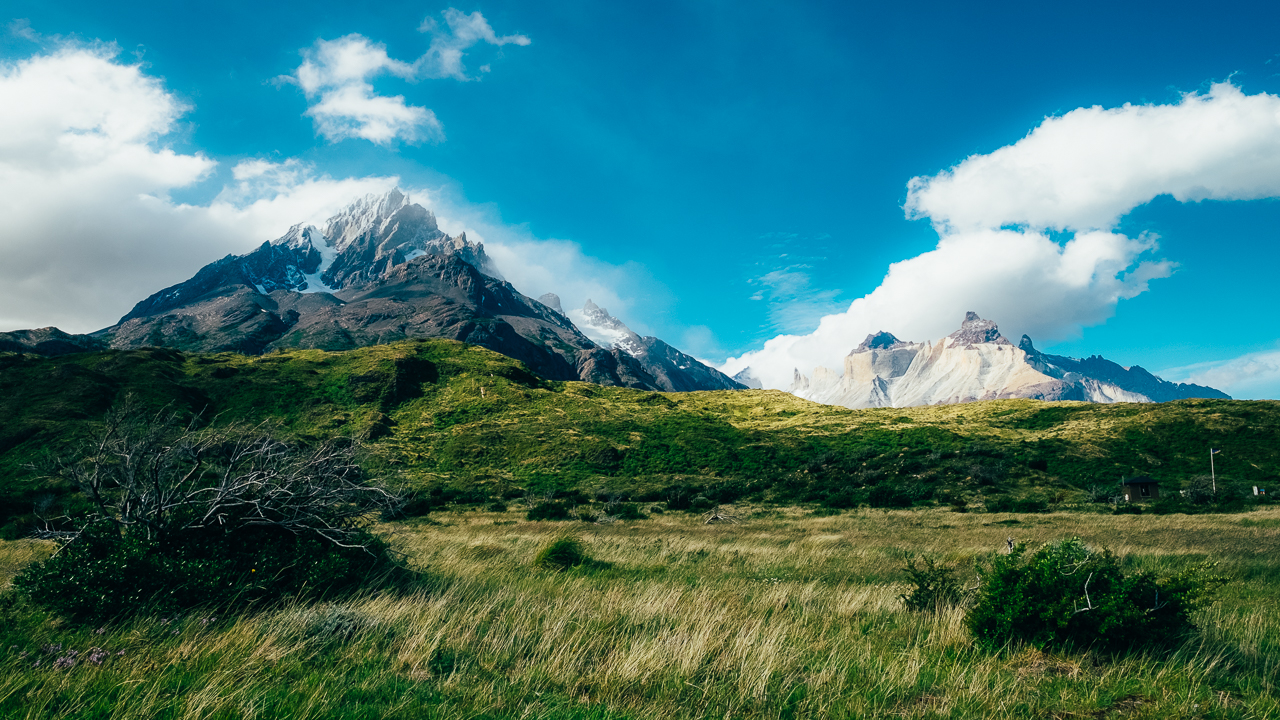
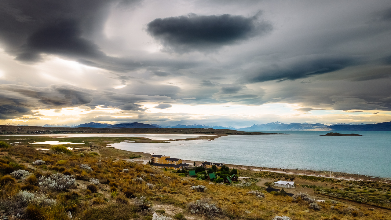
Once we reached the Refugio Paine Grande (which is another five-stars hotel more than a shelter), we were rewarded by an insane view on the Paine Grande and the Cuernos (the top photo).

I would add that walking in strong winds with the big backpack proved to be a bit more tiring than I anticipated. It took a while to get used to being push left, right and front (luckily not back, that would be actually very frustrating). Good gears (GoreTex soft shell in particular) are required to keep warm, which makes a huge difference. But that first day been short, with not a lot of elevation gain, it ended up been a pleasant introduction to Torres del Paine famous weather.

Enjoy (or not) and stay tuned !


Torres Del Paine day 1 – Approaching via Lago Grey (Chile)

Hi !

An epic journey to Patagonia has to be with a stop to Parque Nacional de Torres del Paine, a true natural wonder of world. But before I dive into the adventure we had there, I’m gonna start with approaching this visit, one that need planning and understanding what you going to put yourself to.

Our initial plan was to make the O circuit, a 120km trek, 8 days of walking in unpredictable weather conditions and 7 nights of sleeping in what can range from the five-stars shelters to the miserable campsite bashed by the winds and soaked by the rain. Our fitness level and fear of living 8 days in wet clothes made us change to the W circuit, a 65km trek over 4 days and 3 nights.

If this costed us una pasta (a lot by Spanish standards) to make that change, it offered us a perspective on the park we forgot completely about: taking time to also visit the rest of the park. And we realise that when taking the boat from the Hotel Lago Grey to the Refugio Grey, during with we received long explanations and enjoyed beautiful views of the Grey Glacier itself (part of the largest ice field of the south hemisphere, making it the largest non polar fresh water reservoir in of that same hemisphere).

I will let you google the Refugio Grey if you would like to see how we spent our first night. Let me say that this is not a shelter, but a five-star hotel… The people doing the O circuit would arrive here after passing the Paso John Gardner, more likely after fighting strong winds and rains that would feel like gravel been thrown at your face, must even rate it a million-stars hotel at that point.

That night in that refugio, it was clear that just going there to walk the circuit (which ever) is not enough, and that we’ll have to comeback to make more small hike and more tours to fully enjoy the park.

Enjoy (or not) and stay tuned !


Patagonian roads, Argentina side (Argentina)

Hi !

I know it has been said and written a billion times, but driving in deep Argentina is not the most entertaining part of traveling there. But when you reach the south of Patagonia, driving on the Ruta 40 is an all different story: every road seems to lead you to a beautiful snow-covered mountain range.

Here you are far from everything that makes up for civilization. It can be 300km between two service station, most of them in place that would barely qualify as a settlement. Almost nothing would reveal a human presence, maybe an estancia every 100km, and most of them just because a sign says so, for the farm itself are usually away from the road.

It actually made me wonder if there was really a point of wasting that much fossil energy to discover this land of a few souls, where climate condition would make it a hell for most of us. Sure you have stunning landscape, and then, why disturbing it for the selfish goal of seen the world.

It is not so much intended to make every one of you a concerned ecologist, just a realization that I have ventured somewhere where thing should have been left as they are.

Enjoy (or not) and stay tuned !

El Calafate (Argentina)

Hi !

Though it wasn’t a long stop on our way to the End of the World, El Calafate has been the first spectacular stop since El Bolson, some 1500km north. Not much to be said though, this is just a quick capture of the evening scenery, but you can see the beautiful lake, the magnificent snow-covered mountains and the vibrant green vegetation, which by themselves summarize the beauty of this place.

A longer stop to El Calafate is planned later in January, when we’ll head back to Santiago. But I rather stay on this first impression.

Enjoy (or not) and stay tuned !

1 2 3